Preparing your journey…
Hike from the western town of Haa to Paro, enjoying incredible views of the Haa and Paro Valleys; as well as panoramic views towards the Himalayan range from Kaleyla at clearer times of year. Visit ancient temples, immerse yourself in Bhutanese traditional culture, and taste unique local cuisine along your way.

All our tours are fully customisable — the itineraries you see are simply a starting point. We'll work closely with you to tailor every detail.
4D 3N Trek from Haa to Paro Itinerary
1 Paro - Haa
On arrival at Paro International Airport today, you will be met by your guide. You will be driven by private vehicle to the town of Haa, with a brief stop en route to take in some breathtaking Himalayan vistas at Chelela which, at 3,810 metres (12,500 feet) above sea level is the highest paved road in Bhutan. As you arrive at Chelela, you may wish to join with your guide and driver in a hearty cry of ‘lha-geh lu!’ (‘May the Gods be victorious’).
You will be given time to settle in to your hotel in Haa and to rest before joining your guide for an afternoon acclimatization walk around the town. Your orientation walk will include a visit to the Lhakhang Karpo or ‘White Chapel’ complex, just south of Haa’s Dzong (fortress). The Lhakhang has an atmospheric central chapel which houses statues of the Tse-la-nam Sum trinity. During your visit to the Lhakhang Karpo, you will have the option of a traditional pre-expedition blessing in preparation for your upcoming two days of trekking on the Trans Bhutan Trail.
Your guide will select a local restaurant in Haa for dinner this evening, which will be your first chance to learn about and sample Bhutanese cuisine.
Meals: D
2 Haa – Katsho – Ngopa (Paro)
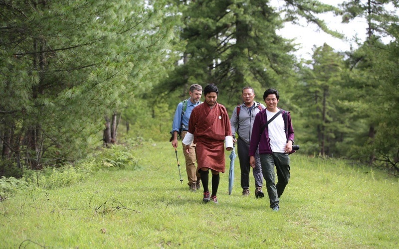
After breakfast at your hotel, you will be transferred to Katsho, where you will begin your first day of trekking on the ancient Trans Bhutan Trail. For generations, the people of Haa followed the route you will walk today to trade with the Parops in the neighbouring valley. There, they would barter 20 drey (approximately 30 kilograms or 66 pounds) of Shakam (dried meat) for 20 drey of rice at Paro Tshongdu (market) because the harsher climatic conditions in Haa are unsuitable for rice cultivation.
The age-old trail follows the beautiful Haa river as it gently rises out of the Katsho Valley, passing through yak pastures before heading into forests of pine and rhododendron. As you traverse the Katsho Valley, look out for cliff-edge Bjungneydra Taktsang (monastery), also known as “The Mini Taktsang”, and the sky burial site of Kungkarpo. The Trail continues to climb until it reaches the pass at Kaleyla, where it crosses the ridge trail between Chelela and Sagala. At Kaleyla, you will enjoy stunning views of the Himalayan range to the north, including on the clearest days vistas of Mount Jomolhari (7,314 metres/23,996 feet), Mount Jichudrakegang (6,794 metres/22,290 feet) and Mount Tsherimgang (6,789 metres/22,273 feet). You will be provided with a picnic lunch during this stop.
From Kaleyla, the trail descends through rhododendron and bamboo forest into the Paro Valley. The last few kilometres to Paro will then be on tracks which meander through traditional Bhutanese farming villages.
On arrival in the Ngopa village of Paro you will have the chance to visit Kichu Lhakhang (temple). Said to date from the 7th century and built by Songtsen Gampo, it is one of Bhutan’s oldest religious sites. Kichu Lhakhang is home to an original statue of Jowo Jamba which is one of the most sacred sculptures in the region; and the two orange trees inside the monastery courtyard are said to bear fruit year round.
Your guide will arrange for dinner either at your hotel or in a local restaurant.
Meals: B,L,D
Trek Distance: 17 kilometres (10.57 miles)
Estimated Trek Duration: 8 hours
Elevation Gain: 1,169 metres (3,835 feet)
Starting Elevation: 2,801 metres (9,190 feet)
Ending Elevation: 2,380 metres (7,809 feet)
Maximum Elevation: 3,790 metres (12,435 feet)
3 Ngopa – Dopshari (Paro)
After breakfast this morning, rejoin the Trans Bhutan Trail heading east. The Trail rises gently from Lamgong Village as it traverses the sprawling rice paddies of the Paro Valley, before carving around the northern ridge and descending into the traditional village of Dopshari.
At Dopshari, enjoy a cookery demonstration and a traditional Bhutanese lunch at a local farmhouse. After lunch, you will also have the opportunity to try your hand at Bhutan’s national sport, archery, and have a quick game of traditional ‘khuru’ (darts).
After lunch, head out onto the trail for one last time for the climb up to Upper Dopshari, where you will enjoy stunning views out over the Paro Valley.
You will be collected from Upper Dopshari and transferred back towards Paro. En route, visit Ta Dzong or the ‘watchtower’, originally built in 1649 to protect Paro Dzong from the Tibetan military. In 1968, Ta Dzong became Bhutan’s National Museum, and is now home to a number of exhibitions including sculpture, painting and artifacts depicting Bhutan’s magical past. Afterwards, continue to the stunning Paro Rinpung Dzong (fortress), meaning ‘Fortress on a Heap of Jewels’. The original construction of this dzong is believed to have been completed in 1458 and it was restored to its present glory by His Majesty the Third of Bhutan, King Jigme Dorji Wangchuck, to mark his royal wedding in 1951.
After your visits, head to your hotel, where we recommend you relax and unwind after your trek in a traditional Bhutanese hot stone bath before enjoying a farewell dinner with your guide at a nearby restaurant.
Meals: B,L,D
Trek Distance: 16 kilometres (9.94 miles)
Estimated Trek Duration: 6 hours
Elevation Gain: 943 metres (3,049 feet)
Starting Elevation: 2,380 metres (7,809 feet)
Ending Elevation: 2,826 metres (9,272 feet)
Maximum Elevation: 2,826 metres (9,272 feet)
4 Depart Paro
After breakfast today, you will be transferred to the airport for your international departure flight.
Meals: B


Community Partners
Your journey contributes directly to local communities. Complete a feedback form after your tour and Druk Asia will donate to your chosen cause.
 Gyalyum Trust
Let's Customise Your Dream Bhutan Adventure
Join over 22,940+ happy travellers who've trusted our Bhutan experts to craft journeys that are anything but ordinary.
- Visa guaranteed — or your money back
- Pick your perfect stay — charming farmstay or luxe hotel
- Design your day — change activities even while you're in Bhutan
- Add a vibrant festival — timing around Bhutanese celebrations is pure magic
- Hike more, or hike less — totally your pace
- Experience Bhutan like a local — hot stone bath, cooking session, astrology reading
What Our Travellers Say
Druk Asia has strong networks with DrukAir and local tour agencies, making logistics a total breeze. The itinerary was well-planned yet flexible enough to accommodate different needs. We could decide when we wanted to get up, which places to visit or simply recuperate in solitude. Will go with Druk Asia again if I were to go back for spring or autumn. Won’t have it any other way!
My trip to Bhutan was pleasant and well organized by Druk Asia. I was very happy and comfortable with my tour guide, Tshering, and had absolute confidence in my driver, Chimmi. Tshering kept me entertained throughout the trip with histories and stories about Bhutan while Chimmi was an excellent driver. Bhutan is a very beautiful country with its unique Buddhist culture and a nation of very warm people. The sceneries were spectacular and its culture charming. I will definitely visit Bhutan again and recommend Druk Asia to my friends.
I knew this Druk Asia through my friend who initially asked me to go to Bhutan. I have to say this travel is excellent. We went to Bhutan through Thailand and the next day we missed the flight. Bhutan’s flight is a bit strange in a sense that we need to be at Thai’s airport 2 hours before departure. The gate closed quite early. Druk Asia helped us a lot to arrange our next day flight. During our time in Bhutan, this travel agent frequently asked our condition there whether we were alright or not. This sense of caring is simply excellent, particularly for the country like Bhutan which is in the Himalayan continent. I really grateful to go to this country with Druk Asia. Excellent!
Just wanted to let both of you know that we had a great time in Bhutan. Thanks for looking into the details. Both our guide and driver were great. Thanks again!
Back from Bhutan, I wanted to let you know that this has probably been the best holiday I ever had. Bhutan is really a wonderful place, the people are so friendly and the landscape gorgeous. We also had the best weather one could ask for, and that helped. We have been very happy the whole tour. One suggestion I would give you is to propose your future clients to spend 1 night in a farmhouse. We did, and we loved it. The host was absolutely nice and the experience of sharing dinner, breakfast and the ordinary life of a Bhutanese family was absolutely fantastic.
An unique experience! We had wonderful time in Bhutan. Though it was a short trip, we enjoyed natural beauty, spectacular view and warm friendly people. We have been many countries but this trip was something different, ...memorable and nostalgic.
