Bhutan, often referred to as the "Land of the Thunder Dragon," covers an area of 46,500 km², making it comparable in size to Switzerland. Spanning approximately 3° of longitude and 1.5° of latitude, Bhutan’s lowest point lies at 150 metres above sea level on the southern border with India, while its northern frontier is marked by the Himalayan mountain range, featuring peaks soaring above 7,000 metres.
Over 70% of Bhutan’s land area is covered in forests, showcasing the country’s commitment to conservation. Approximately 10% of the area consists of glaciers, rocky terrains, heathlands, and alpine pastures. Cultivated land, however, accounts for just 8%, providing sustenance for Bhutan’s population of around 800,000 people.
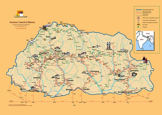
Bhutan is divided into three main regions: Western, Central, and Eastern Bhutan, separated by high mountain passes such as Pelela Pass between Western and Central Bhutan and another prominent pass demarcating Central and Eastern Bhutan.
Main Entry Points to Bhutan
There are three primary entry points into Bhutan, catering to both international visitors and travellers from neighbouring India:
-
Paro International Airport : Bhutan's sole international airport is located in Paro, a one-hour drive from the capital, Thimphu. It is the most convenient entry point for travellers, connecting Bhutan with destinations in Singapore, Thailand, India, Nepal, and Bangladesh through the national airline, Drukair.
-
Phuentsholing : Situated on Bhutan’s southwestern border with India, Phuentsholing serves as a key entry point for Indian traders and tourists. From here, it is approximately a six-hour drive to Bhutan’s interior towns.
-
Samdrup Jongkhar : Located in southeastern Bhutan, this entry point provides access to Eastern Bhutan, making it an ideal choice for second-time visitors looking to explore the Merak Sakteng region or embark on treks in newly opened areas.
Travelling to Bhutan
All international visitors must have a visa pre-arranged prior to visiting Bhutan. However, nationals of India, Bangladesh, and the Maldives can receive visas on arrival, though booking through a tour operator is highly recommended.
By Plane
Flights to Bhutan’s Paro International Airport are available from major cities like Singapore, Bangkok, Kathmandu, Delhi, and Dhaka. Paro’s altitude (2,225 m or 7,300 ft above sea level) and its location surrounded by 4,876 m (16,000 ft) peaks make landing here a breathtaking experience. Bhutan also offers domestic flights to Bumthang (Central Bhutan), Trashigang (Eastern Bhutan), and Gelephu (Southern Bhutan).
Here are more details on how to travel to Bhutan :-
Travelling to Bhutan from Singapore
Travelling to Bhutan from Bangkok, Thailand
Travelling to Bhutan from Kathmandu, Nepal
Travelling to Bhutan from Australia
Travelling to Bhutan from Malaysia
Travelling to Bhutan from USA
By Land
Bhutan’s three land entry points are along the southern border with India:
No border crossings are available on the northern border with China. All required road permits are handled by the tour operator managing your trip.
By Bus
-
From Kolkata: A government-run bus service operates to Phuentsholing, departing from Esplanade Bus Station on Tuesdays, Thursdays, and Saturdays at 7 PM.
-
From Siliguri: Frequent buses connect Siliguri with Phuentsholing. Government buses depart daily at 7:30 AM and 1:30 PM.
-
From Phuentsholing to Thimphu: Bhutan Post buses leave at 7 AM daily.
By Train
Though Bhutan has no railway system, the closest stations in India include:
-
Hasimara (17 km from Phuentsholing): Convenient for travellers arriving from Kolkata or Siliguri.
-
New Jalpaiguri (NJP): Located in Siliguri, this is a popular hub for shared taxis and buses to Bhutan’s border town of Jaigaon.
Exploring Bhutan by Road
Bhutan's national highway connects key towns across the Western, Central, and Eastern regions. Travelling the entire stretch of the highway typically takes about 14 days, covering major destinations while bypassing smaller, remote towns.
|
5 Days
|
Thimphu, Paro, Punakha
|
|
7 Days |
As above, Punakha, Gangtey or Haa valley |
|
10 Days
|
As above, Trongsa and Bumthang
|
|
14 Days
|
As above, Mongar, Trashigang, Trashiyangste
|
Visitors can explore districts such as:
This journey offers breathtaking views of Bhutan’s pristine landscapes and a chance to experience its rich cultural heritage.
Bhutan’s diverse entry options and scenic road networks allow travellers to experience its unparalleled natural beauty and rich culture. From forested valleys to majestic mountain ranges, Bhutan offers an unforgettable adventure, whether arriving by air, bus, or overland from India.
